When speaking about the geography of Qurand, it must be stressed we speak about Solid Qurand, or the hardest form of the matter Qurand consists of. If we wished to chart the entire Qurand without this restriction, we would be unable to illustrate it on a flat map, or even a globe. Soft Qurand is a vast world bound to its solid counterpart in potentially any place, extending outside of the basic map and onto a branching tree of ethereal spaces. Soft Qurand is home to many realms or, among other things, Places of Power that retroactively influence the events happening in Solid Qurand. However, as mentioned above, the countless intertwined paths leading through realms large and small are so many they cannot be described or drawn in simple three dimensions.
Soft Qurand then flows seamlessly into dreamlike worlds called Urulóka or Urulókás, with no clear boundaries. In them, the fabric of reality is so malleable that it succumbs easily to the power of thought and will.
Only two places in Soft Qurand cannot go unmentioned: Paragand, the seat of the Andals, and Aparagand, the seat of the Zilaths. Their respective locations are precisely above and below the navel of Qurand, but the paths leading to them are hidden.
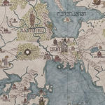
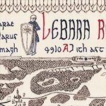
A map of the known world made under the rule of Consul Sefir: the western ocean of Antalas and the continent with Garion in the centre, the land bridge with the Sirania Empire separating Maranudran in the north and the ocean of Kira Samudran in the south, and the Gandharian Empire in the east.
As can be seen on the large map above, the known portion of Solid Qurand consists of two continents, the western one called Mandia and the eastern one called Oria. These continents are connected in two places: the far North, and then the temperate zone by the land bridge on which the Siranian Empire lies.
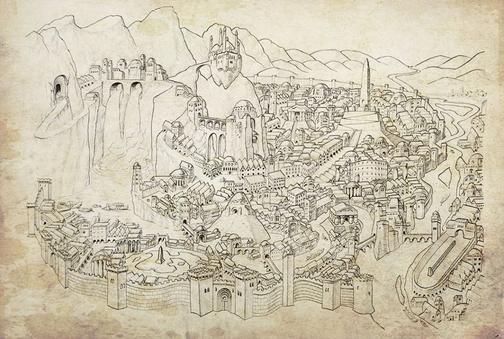
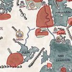
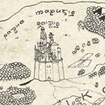
The centre of Qurand is Garion, the Eternal City, the Pillar of Gods. The immensely vast Garion was built ages ago by the Azharians as the seat of their Great Kings, the Rulers of the Universe. Today, the Throne of the World is occupied by a stone statue of the last king who died and left the throne without taking a single step. Nowadays, Garion is the largest city in the world, a centre of wealth, trade, and culture.
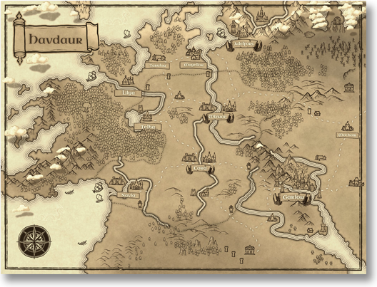
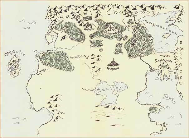
To the west off Garion lies Havdaur, the Kingdom of the West, and further still, tiny kingdoms and principalities subjected to it. In these latitudes, dense western woods extend all the way to the windy shore of the World Ocean, whose waters are dominated by ships from the sea kingdom of Argolin, the land of the Dark Elves. Beyond the mountain ridges of the Argolin archipelago is nothing but an endless sea. According to whispered legends, somewhere in the far west, beyond Argolin, once existed another vast continent but it disappeared below the surface of the sea.
To the south of Garion lies the land-locked Sea of Sgallen surrounded by the fertile lands of Garion. Still further to the south extend the grassy steppes and later the Great Desert, the home of the Southern folk and their culture, which is both rough and refined. Few know what lies in the Far South beyond the Desert.
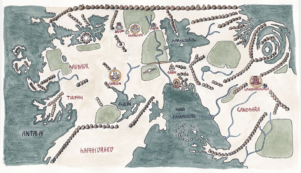
North of Garion lie the old venerable kingdoms of men, the northernmost of which is the Kingdom of Uldar. Uldar extends between two swift creeks that run together at its southern border forming the Ma Sarit. Old stone cities, castles, roads, and deep forests are the pride of these lands. Sometimes, the kingdoms will fight one another as to not get out of practice, while at the same time anxiously avoiding the destruction of villages or sanctuaries and killing unarmed citizens. These military clashes are rather athletic tournaments carried out by agreed-upon rules.
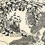
Beyond dark deep woods to the north-west of the kingdoms, on the southernmost reach of Kaal-Charmath, lies the dreadful city of Xalgon – the notorious centre of dark magic. The Academy of the Midnight Knowledge in Xalgon, an agelong antipole of Sairis, is fully in the clutches of the Zilaths. In the heart of the woods dividing Xalgon from the Northern kingdoms, towers a steep-sloped mountain and on it, the ancient city of Valarkagas. Valarkagas is always on guard against Xalgon, and it is the eye of the order that monitors the Zilath activity.
In the Far North, around and beyond Uldar, extend the vast forests of the northern Elven kingdoms and behind them, a tundra inhabited only by the tenacious tribes and sparse villages of the brave and resilient Norsemen. Above their heads, as indeed across the entire North, towers the terrible mountain range of Kaal-Charmath, which on a map gives the impression of a sharp line separating the polar regions from the rest of the world.
To the north of Kaal- Charmath there is nothing but frozen lands, the home to shamanistic tribes, whose members swish across the endless ice-mirrors of their world on their bone-made ice-skates. They live in homes carved in the ice called “chirbets”; their shamanic foremen are called “haugi”. These shamans are said to be descended from Maghavans.
To the east of Garion stretch the peaceful and fertile lands that feed the Eternal City with crops yielded by their fields. Further in the same direction lies a strange territory called the Free Land. Since time immemorial this region belongs to no one; only sparsely inhabited, its cultural centres are the family hearths of the village elders and merry inns by the roads winding and crisscrossing the country. The Free Land is guarded against expansion from other states by the powerful Palladin Order, which encircled this uninhabited and largely unimportant region with a border of little fortresses and castles.
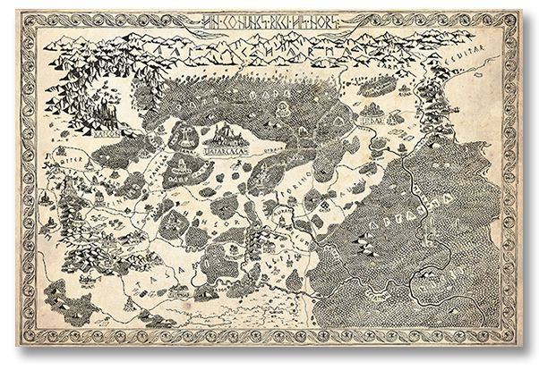
To the north of the Free Land extend the vast woods of the Elven folk, whose easternmost end can be seen in the north-western corner of the map of Sirania. Few have ever explored the labyrinthine depths of the Elven realm; it is the softest part of Solid Qurand and its core lies outside the maps of this world. A great river called Ma Sarit flows through the heart of the kingdom, naturally dividing into the Western and Eastern Realm.
The western banks of Ma Sarit mark the end of the Free Land, the Siranian territory beginning on its eastern banks. The detailed description of Sirania can be found in the numerous accompanying pages.
More to the east, beyond the Siranian Empire, lies Gandhara, whose expanse is enormous. You can read more about its centre, Gandharnagara, in a separate section.